Flying into the future: drones and water quality in Northumbria
The UK has made a huge effort to clean up its waterways in recent years. As extreme weather events become more common, they can have a heavy impact on the quality of British rivers, lakes and coastal areas. To understand how to mitigate that impact, Northumbrian Water needs more real-time data on water quality and so is sending drones into the sky.
Water quality matters to the people concerned about drinking water, the environment and those using waterways for swimming, surfing and other sports and recreation. Addressing these concerns, Northumbrian Water works closely with regulatory bodies and publishes its goals for water quality for the public.
Different water environments present different challenges for continuously monitoring water cleanliness. They encompass four major categories: inland bodies (rivers and streams), inland complexes (lakes), estuarine environments (where a river flows into the sea) and coastal areas.
Northumbrian Water works closely with regulatory bodies and publishes its goals for water quality for the public.
“Sondes” like a good idea
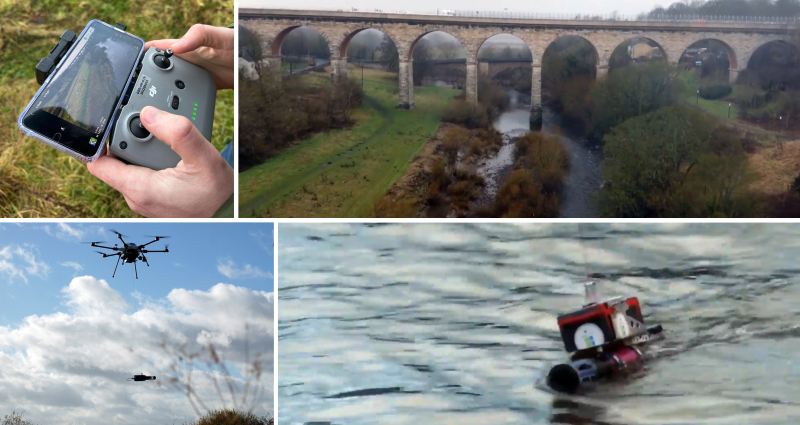
The principal tool for measuring water quality in near real time within these environments is a sonde – a tube that carries a range of sensors that can detect different pollutants. Currently, sondes are incorporated into fixed automated stations that are either positioned next to a body of water or, in coastal environments, in floating buoys. Typically, the sondes measure water quality once an hour, but they are required to increase their sampling frequency to every 15 minutes during a high-risk event, such as prolonged or intense storms. They rely on the cellular network to transmit data results to Northumbrian Water headquarters.
There are two types of sonde deployments: kiosk deployment and suitcase deployment, named after the appearance of the housing unit the sonde sits in. These automated stations require monthly maintenance and calibration under normal functioning. While some are powered by solar panels, others have fuel cells that need people to visit them for replenishment on a regular basis. Animals, vandals and extreme weather can damage them, requiring emergency repairs. They are sometimes located in remote, inconvenient locations, on public or private property. All this adds up to a huge amount of people-hours and carbon-intensive transport. Extreme events damage equipment and block access to units, just when you need more data, not less.
Measuring quality in estuarine and coastal areas can involve people in boats either doing the measurements themselves or maintaining sondes located on buoys. It’s very people-intensive and can be dangerous in rough conditions.
In all these environments, flying drones can make a difference. If a fixed station breaks down, a drone can be sent to the location to cover for it. If an estuarine plume (outflow of a river into the ocean) moves away from a buoy, a drone can follow it. At least, that’s the idea.
Fly, test, report
Northumbrian Water has set out to test that idea and, since March 2023, has made great strides in moving the project forward. It is innovating by combining technological solutions with drones to improve the frequency and quality of continuous water reporting in a more efficient manner than traditional technologies, such as the kiosk, suitcase and buoy deployments. They have brought together partners for data capture and analysis (Makutu), flying drone deployment (Skyports) and sondes (RS Hydro).
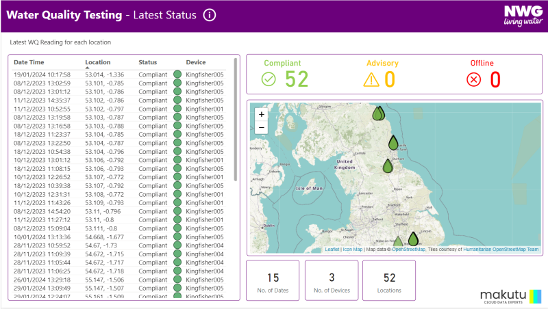
This combination of expertise and technologies is needed as the sonde reports on water quality instantly while it is submerged in the water body. The drone hovers over the waterway to be tested and lowers the sonde directly into the water. The results are transmitted to Northumbrian Water headquarters. Northumbrian Water aims to make data available hourly once the trials have successfully concluded and drone deployment is firmly established for regular use.
It is innovating by combining technological solutions with drones to improve the frequency and quality of continuous water reporting
Phase 1 of the drone project was an on-paper study to estimate the feasibility of using drones in different environments. For example, it was determined that only 38% of inland river areas could be measured using drones due to overhanging obstructions such as trees and other obstacles to flight. Fast-flowing water was deemed too forceful for the drones when the sonde was submerged in the water course. Estuaries tend to have a lot of boat traffic which could be challenging for low-flying drones.
Phase 2 began using the combined technologies in the field.
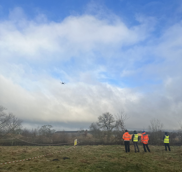
Testing typically involves two teams of people – pilots who operate the drone and “spotters” who watch the environment to identify potential hazards, such as people. Northumbrian Water teams discovered that drones have performance limitations in very high wind conditions or sub-zero temperatures (including the risk of freezing propellers). Key learnings from the phase 2 trial proved invaluable for shaping future trials.
Phase 3 is launching this summer, the peak period for people to be in the water and most interested in daily conditions. Teams will still have local spotters on-site, with phase 3 trials conducted over a longer period, collecting data at a higher frequency along coastal and estuarine water bodies.
Phase 4, coming later, will see testing with “spotter-free” flights, mostly in controlled environments such as lakes with restricted access to the public, with pilots being remotely stationed hundreds of miles away.
Future regulatory changes may allow for fully automated drones or “pilot-only” flights of drones. Northumbrian Water is also considering testing submarine drones for estuarine or coastal areas. The longer-term objective is to have (drone) pilots based up to 200 miles away, possibly even in London. Remote piloting can open up the field to people who may be mobility challenged.
Northumbrian Water has moved this programme ahead at lightning speed and is looking forward to providing more frequent and comprehensive data on water quality as technology advances.
The longer-term objective is to have (drone) pilots based up to 200 miles away, possibly even in London.